Rafting |
Cameron |
Havasu |
Sky Walk |
North Rim |
|
|
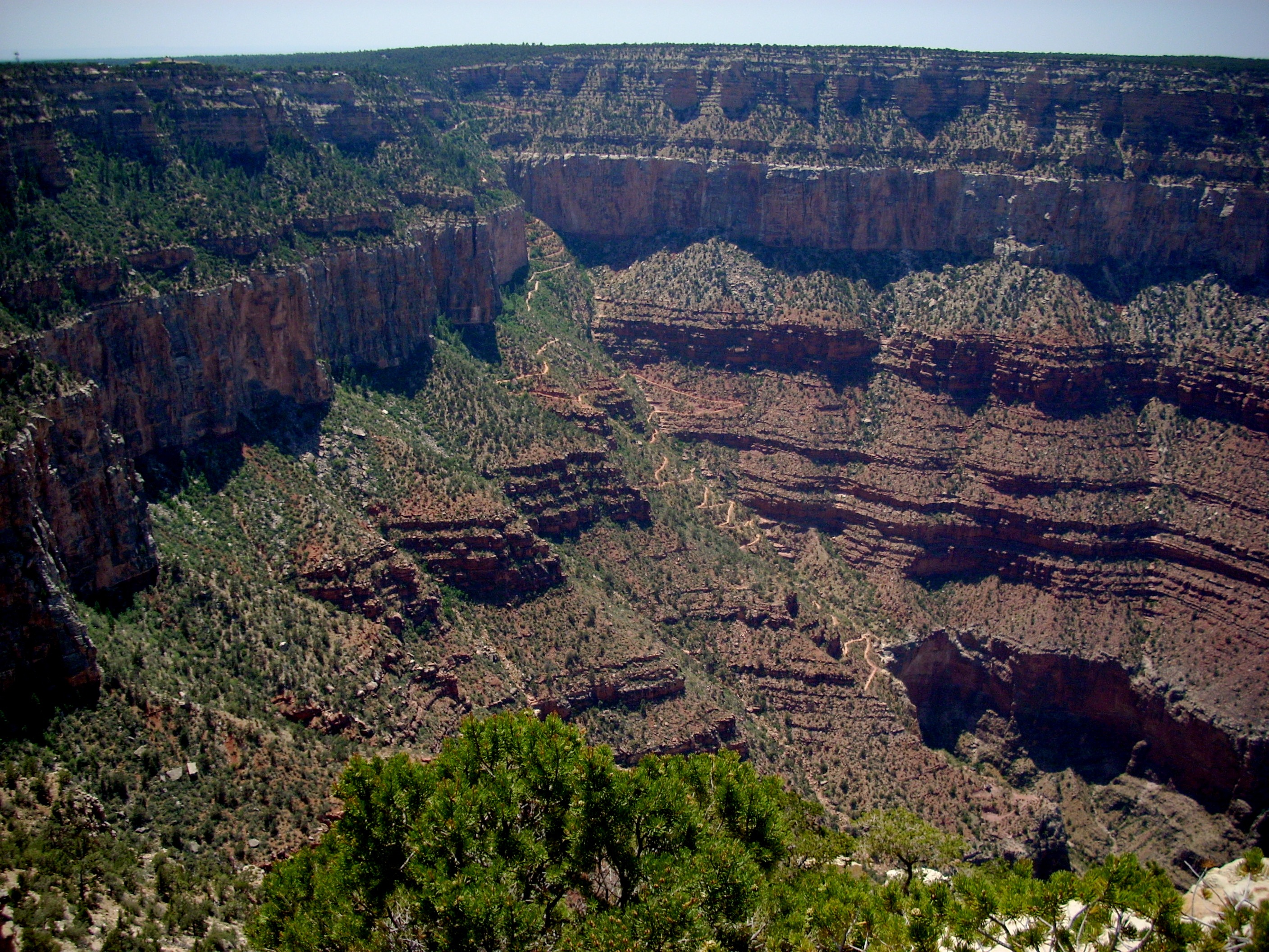
| Hiking | South Rim | West Rim | Boucher | South Kaibab | Hermit | Grandview |
Bright Angel Trail is probably the most famous day hiking trail in America and one of the most famous in the world. You quickly realize this when you hike it. The other hikers on the trail with you are from every corner of the country and from all around the world. Rest stops are like a United Nations gathering. It is so popular for several reasons. The trailhead is in the very center of Grand Canyon Village, so this is the most accessible hike in the park. This is one of only two trails from the South Rim down to Phantom Ranch. It is a photographer's fantasy. Anyone even vaguely interested in Geology considers this a classic experience since the trail cuts through so many rock layers. And among the hiking fraternity, it's a rite of passage. Once you've hiked down to Indian Gardens and then survived the hike back up to the Rim, you've proven yourself. Bright Angel Trail is the ideal first hike below the Rim. It presents the conditions common to the other trails, but in a safer and more manageable context. There are the three water sources. There are always other hikers and even mule trains coming by. There's shade down at Indian Gardens. Tthe distance is reasonable. And it's nice that as you emerge back onto the Rim, there's a snack bar and ice cream counter only a few steps away. |
 |
 |
During peak season, a park ranger usually monitors everyone starting down to make sure they're properly equipped, know that it will take them three times as long to get back up than to walk down, and are carrying adequate water and sunblock. They also caution everyone NOT to try to hike to the river and back in one day. All the brochures handed out in the lodges and the ranger advice have pretty well acquainted people with the challenges involved, so many of them will only hike down to the first or second water stop, rest, then hike back up. But the classic hike is still to Indian Gardens and back. Done properly this is an all day excursion. The MILEAGE is not impressive by the usual hiking standard. It's the ELEVATION CHANGE that is challenging. From the Rim to Indian Gardens is 4.9 miles, making a round trip of 9.8 miles. But the total elevation change is 7074 ft., enough to stress even fit hikers' calf and thigh muscles and cardiovascular systems. |
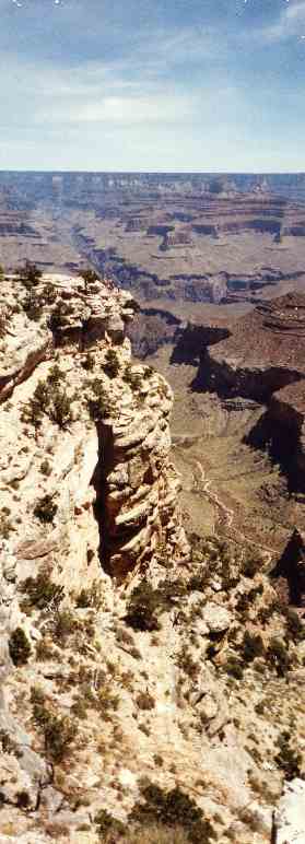
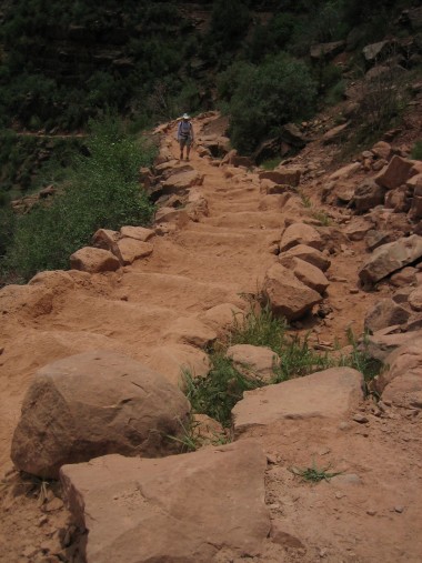
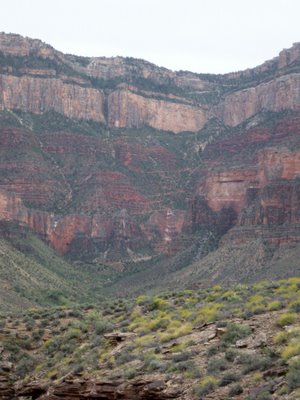
Here we are looking down on Bright Angel Trail from the South Rim Trail. This is one of the more famous stretches of the trail, called Jacob's Ladder. It zigzags down the drainage in short segments for a mile. These are steep zigs and zags. Make sure your hiking boots have plenty of room in the toe box. If your toes keep impacting the front of the boot on every downward step, you'll have quite a blister, probably on your big toe, by the time you get to Indian Garden. Jacob's Ladder descends through the Redwall Limestone. From this distance, it does look red, which would indicate iron. But it's an illusion. Down on the trail, you'll be close enough to see what's really happening. The original limestone is whitish-gray, but has been stained over the centuries by iron leaching down from the layers above. You can scratch away the reddish surface and get down to the soft whitish-gray underneath. Close up, you can also see how the reddish stain is richer where water seeps more. |
 |
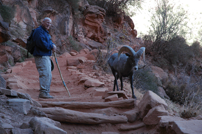 |
The terrain seems inhospitable at first glance, but as you descend, you'll see lots of life. Probably the most interesting are the Desert Bighorn Sheep. They climb what seem like sheer cliffs. They're pretty used to the daily stream of hikers, so you may see one quite close to the trail. Occasionally one may even cross the trail right in front of you, suddenly dropping down from a cliff above, pausing on the trail for only a second, then disappearing over the edge before you can raise your camera. There is a large population of Desert Bighorn Sheep in the Canyon, but wildlife biologists cannot determine exactly how many because the sheer cliffs where the sheep live are inaccessible. They have a unique nine stage digestive system which allows them to extract nutrients from marginal food. For instance, Prickly Pear and Cholla Cacti are among their favorite foods; they have the ability to extract the spines and get to the nutritious tissue inside. They get most of their water from the plants they graze on, so they only visit watering holes or streams once every third day or so. |
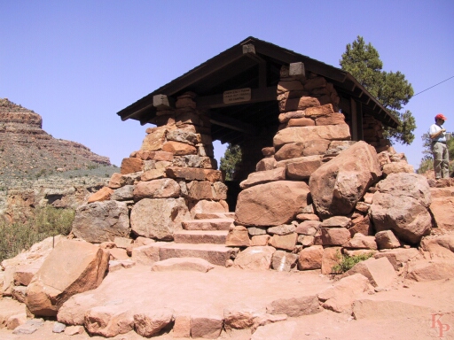
Bighorn Sheep, Mountain Lion and other game originally created the Bright Angel Trail. The Anasazai used it to get up to the Rim, and later the Havasupai used it to get down to the crops they tended at Indian Garden. The Spanish Conquistadors were told of its existence by the Havasupai but tried in vain to find it; Since they never did they never found a route down to the river. Miners and explorers used it in the 1800s. Ralph Cameron arrived at the Canyon in 1890 and immediately saw the potential in the trail as a commercial venture. He bought the rights to the trail from the Havasupai. He built the Half Mile and Three Mile shelters and the restrooms and picnic shelters at Indian Gardens. Then he began charging tolls for hikers and launched the famous mule rides. When the Santa Fe Railroad built their line into Grand Canyon Village and erected El Tovar Hotel, they tried to buy Cameron's trail, but he refused. So the Santa Fe went five miles west, improved the old Horse Thief Trail, renamed it Hermit's Rest Trail, built the Hermit's Rest Station, and sent their guests down that route all the way to the river. When the National Park Service arrived, they also tried to buy Cameron out. Again he refused. So they initiated legal action for the long term, using the Law of Eminent Domain. In the meantime, they created a brand new trail, the South Kaibab, as an alternate route to Phantom Ranch. Finally, they wrested control of the Bright Angel from Cameron, who went on to a career in the U. S. Senate. So the Bright Angel Trail, along with its mule rides, Indian Garden Campground, and two shelters, entered the modern era. Today, composting toilets have been installed at Indian Gardens. The debate over mule rides continues. Park administrators believe the mules damage and foul the trail and would like to end them, but the mules have become a 100 year old tradition which is an important part of park history. Public outcry has so far saved the mules. However, in 2012 the one day down and back ride to Indian Point (way out at the end of the Tonto Plateau from Indian Garden) has been suspended despite public protest. |
 |
 |
Below Jacob's Ladder you alternate short level stretches with more switchbacks. If you wear one of those belt hook thermometers and check it often, you'll notice the further you descend the hotter it gets. Temperatures at Indian Garden range from 5 to 10 degrees higher than the South Rim, and at Phantom Ranch they range from 10 to 20 degrees higher. |
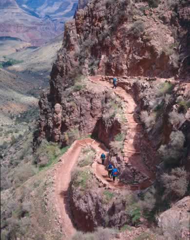
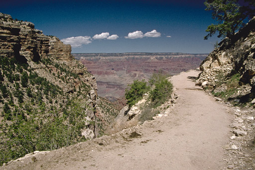
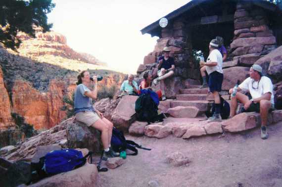
You need to pace yourself. The first shelter is half a mile down. This is a good place to top off your bottles and pause in the shade for a while. In this photo, there is no shade, but back along the trail there are bushes and small trees which provide a small amount. From this first shelter it is 2.5 miles to the second shelter. We suggest you hike about a mile, stop for a drink and to cool off, then hike another mile, stop, then hike the last five tenths of a mile. Again, we recommend topping off your bottles. If you're drinking water right along, you should need more at each shelter. From Three Mile Shelter to Indian Gardens is two miles. We recommend hiking this in one mile increments. We also recommend changing socks and tetalcing, and reapplying sunBLOCK each time you stop. |
 |
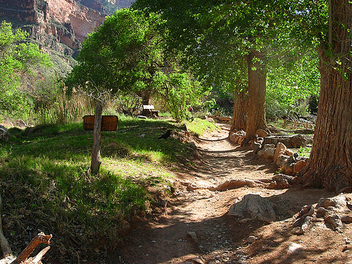 |
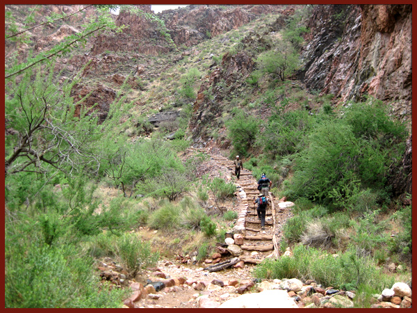
Indian Garden is a beautiful little oasis. There's a stream here, considerable shade, benches, picnic tables and of course modern composting toilets. The average hiker reaches Indian Garden in about 2-3 hours, depending on how often they stop for photos. We recommend lunch either here or out the side hike to Plateau Point (see text and photo below). Find a cool shady place near the stream, take off your boots and socks and stick your feet in the water while you munch on your sandwich. Take a nap. Study your topo map. Spend some time looking at the canyon from this inner viewpoint. Watch the Ravens riding the thermal updrafts. There are very few lunch stops anywhere in America that are as idyllic as this, so you should soak it all in for future memories. |
| Indian Gardens is also a campground. It has water, composting toilets, tables, shelters and tent pads. You have to make reservations well in advance, but it makes for a convenient overnight if you don't have too much time and don't want to plan a longer trip into the canyon. If you have time and energy on your day hike, in addition to the side hike out to Plateau Point, you could hike East or West on The Tonto Trail for a mile or so. It traverses the Tonto Plateau, and gives you lots of great photo angles looking back up toward Yavapai Point, Yaki Point, Maricopa Point and Hopi Point. |  |
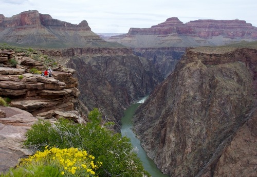 |
Plateau Point is the famous side hike out across the Tonto Plateau from Indian Gardens. The overlook, shown here at left, offers breathtaking views of the Colorado River. With a good pair of binoculars you can watch the white water rafters navigating the rapids far below. The Park Service used to offer mule rides from the rim down to Plateau Point, lunch at the Point, and a leisurely ride back, with potty stops both ways at Indian Gardens. They discontinued those, and still receive demands every year to reinstate them. It's only about a 30 minute walk from Indian Gardens out to the Point, along level trail. It makes a great lunch stop. |
| Indian Garden, because of its water, is a magnet for wildlife. Especially common are the Collared Lizards which skitter along the rock walls, bask in the sun, perch on the sides of trees and rustle through the leaf litter. They're accustomed to hikers, backpackers and mule trains and have little fear unless you try to pick one up. They're not dangerous to you. They live mostly on insects and invertebrates. If you tried to pick up one of the larger ones it would try to bite you, but instead of teeth or fangs it has only sharp bony gum ridges. They can slice through a larva, beetle, or smaller species of lizard, but not your skin. Depending on when you do your hiking, you might see the males in the full glory of mating season. At those times, as a means of impressing the females, they are brilliant colors : blues, greens and turquoise. The females are very drab for camoflage purposes, except when they're pregnant and show bright red splotches to let the males know to keep away. You will also see plenty of collared lizards as you hike along the trail. They have the surprising habit of standing up and running on their hind legs, and when they do they display a very long stride and great speed and quickness. They use this speed to escape from predators, usually small mammals and large birds. A typical Grand Canyon Collared Lizard lives 7-8 years and grows to about 10 inches long. These are America's most intelligent, most interesting and most attractive lizards so you should study them while you're here. | 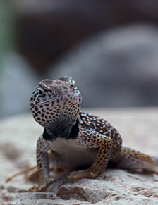 |
 |
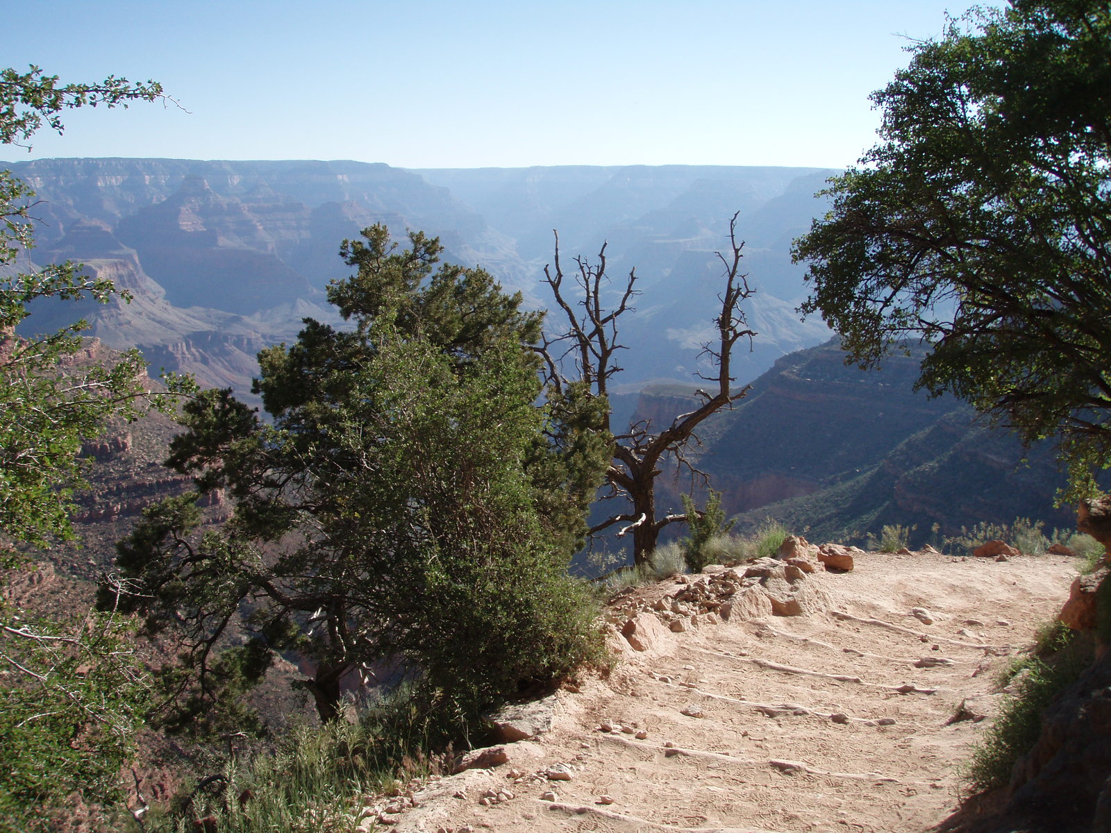
When you start the return trip, this is the scene that confronts you. You'll be climbing 3537 feet in five miles in 100 degree heat. Figure on 4-6 hours. We've done this trip many times. It's really a great hike. In many ways it's better than the descent. But you have to pace yourself, drink lots of water even if you're not thirsty, and change socks and retalc several times. Break the trip into three phases : To Three Mile Shelter, to Half Mile Shelter, and to the Top. You might stop briefly in between each of those, but at those three points you should stop for a longer break, top off your bottles and elevate your legs to give your thighs and calves a rest. Eat a few bites of something : dried fruit, an apple, an orange or a banana. We know people who carry a soft drink, V-8 or Energy Drink and save it for Three Mile Shelter and Half Mile Shelter on the way back. Don't forget photography. You'll not only be looking at everything from a different angle, but the Sun will be several hours further on, and the colors of the rock walls will have changed, probably leaning toward the left side of the spectrum. There will also be deepening shadows, which often makes for interesting photo effects. |
Don't forget to socialize during your rest stops. You'll be joined on the trail by an interesting group of international hikers. They all have stories to tell. A lot of these people have hiked in the Alps, the Dolomites, the Himalayans, the Pyrenees, Hadrian's Wall in England, Mt. Kilamanjaro in Africa and in to Petra in Jordan. When you're stopped, leaning back, resting your feet, take time to glance up at the birds riding the thermal currents. The Canyon has been heating up all day and that hot air is rising in upward spirals. Ravens in particular will ride these spirals just like humans surfing ocean waves. Hiking back up, you're almost certain to be overtaken by the mule trains coming up from Phantom Ranch. The rule is to stand on the UPHILL side of the trail and get as far off the trail as possible, scrunching back against the cliff or stepping into the rocks. |
 |
Comment or
Question ?? Join us at The
Forum. |
Read our day to day adventures at the Blog |
Or contact us at trekkerforrest@aol.com |